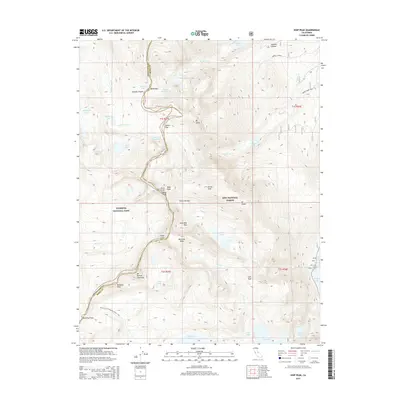
2015 Map of Koip Peak
USGS Topo · Published 2015About this map
Koip Peak and Kuna Peak dominate this high-altitude landscape along the border of Yosemite National Park and Inyo National Forest. The region is defined by its dramatic crests and glacial basins, serving as a critical hydrological divide where headwaters like Kuna Cr and Parker Pass Cr originate. The map illustrates a network of historic high-country routes, including the Pacific Crest National Scenic Trail as it traverses Donohue Pass, and the specialized Parker Creek Trail. Significant peaks such as Mt Andrea Lawrence and Blacktop Peak provide a framework for the local topography, while numerous alpine basins contain landmarks like Gem Lake, Waugh Lake, and the Alger Lakes. This 2015 survey details the precise boundary between Tuolumne and Mono counties as it follows the jagged sawtooth ridges of the Sierra Nevada.
Find a feature on this map
50 named features on this map. Tap any name to fly to it.
Don’t see what you’re looking for? This feature index may not catch every label — zoom into the map to look around manually.
Map Details
Editions of this 2015 Koip Peak Map
This is the sole edition of this map. No revisions or reprints were ever made.
Other maps of this area

1901 · Mt. Lyell
USGS Topo · 1:125,000

1947 · Mariposa
USGS Topo · 1:250,000

1948 · Mariposa
USGS Topo · 1:250,000

1953 · Merced Peak
USGS Topo · 1:62,500

1953 · Mono Craters
USGS Topo · 1:62,500

1953 · Devils Postpile
USGS Topo · 1:62,500

1956 · Tuolumne Meadows
USGS Topo · 1:62,500

1957 · Mariposa
USGS Topo · 1:250,000

1963 · Mariposa
USGS Topo · 1:250,000
1976 · Yosemite Valley
USGS Topo · 1:100,000