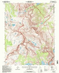
1994 Map of Koip Peak
USGS Topo · Published 1997About this map
Mono Pass stands as a significant historical crossing point along the boundary of Tuolumne Co and Mono Co, marking a high-altitude gateway between the high Sierra and the eastern basin. This 1994 revision captures a landscape defined by its mining legacy, where numerous prospects, a Mine Shaft, and various adits are concentrated near Summit Lake. These markings reflect a period of intensive geological exploration and extraction that once characterized the area's economy. The terrain transitions from the eastern slopes of Yosemite National Park into the Ansel Adams Wilderness and Inyo National Forest. High peaks like Koip Peak and Mount Lewis overlook a complex network of alpine water bodies, including the Alger Lakes and the prominent Gem Lake, connected by drainage systems like Rush Creek.
Find a feature on this map
45 named features on this map. Tap any name to fly to it.
Don’t see what you’re looking for? This feature index may not catch every label — zoom into the map to look around manually.
Map Details
Editions of this 1994 Koip Peak Map
This is the sole edition of this map. No revisions or reprints were ever made.
Other maps of this area

1901 · Mt. Lyell
USGS Topo · 1:125,000

1947 · Mariposa
USGS Topo · 1:250,000

1948 · Mariposa
USGS Topo · 1:250,000

1953 · Merced Peak
USGS Topo · 1:62,500

1953 · Mono Craters
USGS Topo · 1:62,500

1953 · Devils Postpile
USGS Topo · 1:62,500

1956 · Tuolumne Meadows
USGS Topo · 1:62,500

1957 · Mariposa
USGS Topo · 1:250,000

1963 · Mariposa
USGS Topo · 1:250,000
1976 · Yosemite Valley
USGS Topo · 1:100,000