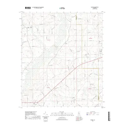
2018 Map of Kokomo
USGS Topo · Published 2018About this map
Magees Cr cuts a diagonal path through this southern Mississippi landscape, defining the rural character of the borderlands between Walthall and Marion counties. The area is marked by long-standing community centers such as Salem, Kokomo, and Knoxo, where local life is anchored by family burial grounds and spiritual sites like China Grove Ch. The terrain rises toward Dillon Hill in the southwest, while numerous small watercourses like Tenmile Cr and Collins Cr drain the timber and agricultural lands that have long supported these settlements.
Find a feature on this map
98 named features on this map. Tap any name to fly to it.
Don’t see what you’re looking for? This feature index may not catch every label — zoom into the map to look around manually.
Map Details
Editions of this 2018 Kokomo Map
This is the sole edition of this map. No revisions or reprints were ever made.
Other maps of this area

1953 · Hattiesburg
USGS Topo · 1:250,000

1953 · Natchez
USGS Topo · 1:250,000

1956 · Natchez
USGS Topo · 1:250,000

1958 · Hattiesburg
USGS Topo · 1:250,000

1959 · Natchez
USGS Topo · 1:250,000

1970 · Sandy Hook NW
USGS Topo · 1:24,000
1970 · Tylertown SE
USGS Topo · 1:24,000

1970 · Kokomo
USGS Topo · 1:24,000

1970 · Mesa
USGS Topo · 1:24,000

1970 · Darbun
USGS Topo · 1:24,000