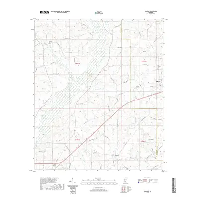
2020 Map of Kokomo
USGS Topo · Published 2020About this map
Knoxo and Kokomo anchor this rural landscape in Walthall and Marion counties, where the Pearl River basin's tributaries carve through the Mississippi piney woods. The settlement patterns follow a network of named country roads, including Griffin Rd and Rushingtown Rd, connecting small communities like Salem and Melis. Genealogists will find a high density of burial sites across the quadrangle, from the family-named Boyd Cem and Spence Cem to the larger Hillcrest Memorial Gardens. The terrain is defined by drainage systems like Magees Creek and Collins Cr, while Dillon Hill provides a distinct topographic landmark. This contemporary survey preserves the placement of many established landmarks, including China Grove Cem and New Damascus Cem, that have served these communities for generations.
Find a feature on this map
99 named features on this map. Tap any name to fly to it.
Don’t see what you’re looking for? This feature index may not catch every label — zoom into the map to look around manually.
Map Details
Editions of this 2020 Kokomo Map
This is the sole edition of this map. No revisions or reprints were ever made.
Other maps of this area

1953 · Hattiesburg
USGS Topo · 1:250,000

1953 · Natchez
USGS Topo · 1:250,000

1956 · Natchez
USGS Topo · 1:250,000

1958 · Hattiesburg
USGS Topo · 1:250,000

1959 · Natchez
USGS Topo · 1:250,000

1970 · Sandy Hook NW
USGS Topo · 1:24,000
1970 · Tylertown SE
USGS Topo · 1:24,000

1970 · Kokomo
USGS Topo · 1:24,000

1970 · Mesa
USGS Topo · 1:24,000

1970 · Darbun
USGS Topo · 1:24,000