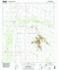
1996 Map of Kom Vo
USGS Topo · Published 2002About this map
The Tohono O'odham Indian Reservation landscape is defined by the ephemeral waterways that drain the desert floor, such as the San Simon Wash and Vamori Wash. Settlements are concentrated along these drainage patterns, including the villages of Kom Vo and Schuk Cowlik. The topography is marked by the distinct elevations of the Kupk Hills, which rise sharply between the Quijotoa Valley and the Kom Vo Valley. A small Cem located near Tatk Kam Vo provides a specific point of interest for genealogical research in this region of Pima County. The map details the intersection of the Gila and Salt River Meridian with township boundaries, illustrating the enduring structural framework of the Public Land Survey System in the Arizona desert.
Find a feature on this map
15 named features on this map. Tap any name to fly to it.
Don’t see what you’re looking for? This feature index may not catch every label — zoom into the map to look around manually.
Map Details
Editions of this 1996 Kom Vo Map
This is the sole edition of this map. No revisions or reprints were ever made.
Other maps of this area

1953 · Ajo
USGS Topo · 1:250,000

1954 · Sonoyta
USGS Topo · 1:250,000

1957 · Ajo
USGS Topo · 1:250,000

1958 · Ajo
USGS Topo · 1:250,000

1962 · Ajo
USGS Topo · 1:250,000

1963 · Ajo
USGS Topo · 1:250,000

1963 · Kom Vo
USGS Topo · 1:62,500

1963 · Gu Oidak
USGS Topo · 1:62,500

1963 · Quijotoa Mts
USGS Topo · 1:62,500

1963 · Pisinimo
USGS Topo · 1:62,500
Featured Places
- Chukut Kuk District, AZ
- Pisinemo District, AZ
- Kom Vo, Pisinemo District
- Tatk Kam Vo, Pisinemo District
- Pima County, AZ