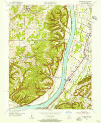
1955 Map of Kosmosdale
USGS Topo · Published 1956About this map
Ohio River bottomlands and the rising hills of the Taylor and Posey districts dominate this mid-century landscape where Kentucky and Indiana meet. The river serves as a major geographical divider, with the Illinois Central railroad and Dixie Highway paralleling the eastern shore through riverside communities like Kosmosdale and Meadow Lawn. Significant military footprints are evident at the southern edge of the map, including portions of the Fort Knox Military Reservation and the Knob Creek Naval Reservation. Small rural centers such as Bethany and Elizabeth are clearly marked alongside local landmarks like Elizabeth Ch and the Kosmosdale Sch. The intricate drainage systems of Mill Creek and Pond Creek illustrate the low-lying terrain near the Jefferson and Bullitt County line, while higher elevations like McHarry Hill provide a contrast to the river valley floor.
Find a feature on this map
63 named features on this map. Tap any name to fly to it.
Don’t see what you’re looking for? This feature index may not catch every label — zoom into the map to look around manually.
Map Details
Editions of this 1955 Kosmosdale Map
This is the sole edition of this map. No revisions or reprints were ever made.
Other maps of this area

1909 · Kosmosdale
USGS Topo · 1:48,000

1912 · Kosmosdale
USGS Topo · 1:62,500

1931 · Corydon
USGS Topo · 1:62,500

1936 · Vine Grove
USGS Topo · 1:62,500

1941 · Ekron
USGS Topo · 1:62,500

1943 · Vine Grove
USGS Topo · 1:62,500

1946 · Rock Haven
USGS Topo · 1:24,000

1946 · Pitts Point
USGS Topo · 1:24,000

1946 · Fort Knox
USGS Topo · 1:24,000

1946 · Vine Grove
USGS Topo · 1:62,500