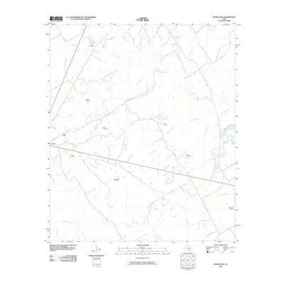
2010 Map of Kosse East
USGS Topo · Published 2010About this map
The town of Kosse serves as the focal point for this rural landscape in Limestone County, where the topography is defined by a dense network of tributaries including Steele Creek, Pin Oak Creek, and Duck Creek. The area is notably rich in family and community burial grounds, which provide significant data for genealogical research. Sites such as Sowders Cemetery, Eutaw Cemetery, and Buttrill Cemetery are scattered across the landscape, often situated near the headwaters of small branches. In the northern reaches, Knox Lake and its associated Knox Lake Dam mark a transition in the drainage of Big Creek. The map details a web of local routes, including Moss Rose Rd and Moss Springs Rd, which connect these dispersed settlements and homesteads. This 2010 survey reflects a modern view of a region that maintains its traditional rural structure, preserved through these small cemeteries and persistent watercourse boundaries.
Find a feature on this map
52 named features on this map. Tap any name to fly to it.
Don’t see what you’re looking for? This feature index may not catch every label — zoom into the map to look around manually.
Map Details
Editions of this 2010 Kosse East Map
This is the sole edition of this map. No revisions or reprints were ever made.
Other maps of this area

1927 · Marquez
USGS Topo · 1:62,500

1930 · Marquez
USGS Topo · 1:62,500

1954 · Waco
USGS Topo · 1:250,000

1955 · Waco
USGS Topo · 1:250,000

1962 · Bremond
USGS Topo · 1:24,000

1962 · Petteway
USGS Topo · 1:24,000
1965 · Bald Prairie
USGS Topo · 1:24,000

1965 · Kosse West
USGS Topo · 1:24,000

1966 · Thornton
USGS Topo · 1:24,000
1966 · Box Church
USGS Topo · 1:24,000