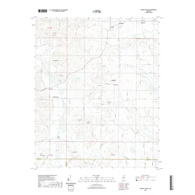
2020 Map of Kossuth South
USGS Topo · Published 2020About this map
Kossuth anchors the northern edge of this landscape where the Hatchie River and Blissdale Swamp define the southern lowlands. The terrain is characterized by a series of prominent ridges and peaks, such as Bragg Mtn and Antioch Hill, which overlook several small, concentrated settlements including Collinstown and Crumtown. This topography influenced the development of local infrastructure, seen in the crossing at Turnpike Bridge and the winding course of Old Stage Rd as it traverses the border between Alcorn, Tippah, and Prentiss counties. Local family history is preserved in several burial grounds, notably Union Cem, Pleasant Grove Cem, and Alcorn Cem, which are situated along the drainage basins of Elliott Cr and Hinkle Cr. The map reveals a rural economy tied to the land, with numerous named hollows like Kellum Hollow and Nancy Hollow tucked between the upland ridges.
Find a feature on this map
96 named features on this map. Tap any name to fly to it.
Don’t see what you’re looking for? This feature index may not catch every label — zoom into the map to look around manually.
Map Details
Editions of this 2020 Kossuth South Map
This is the sole edition of this map. No revisions or reprints were ever made.
Other maps of this area

1921 · Booneville
USGS Topo · 1:48,000

1922 · Booneville
USGS Topo · 1:62,500

1950 · Corinth
USGS Topo · 1:62,500

1951 · Walnut
USGS Topo · 1:62,500

1955 · Ripley
USGS Topo · 1:62,500

1956 · Tupelo
USGS Topo · 1:250,000

1958 · Tupelo
USGS Topo · 1:250,000

1972 · Jumpertown
USGS Topo · 1:24,000
1973 · Booneville
USGS Topo · 1:24,000
1982 · Kossuth South
USGS Topo · 1:24,000