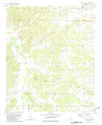
1982 Map of Kossuth South
USGS Topo · Published 1983About this map
Kossuth anchors the northeastern corner of this landscape, where the hills of northern Mississippi meet a complex drainage system of creeks and river bottoms. The area is defined by its small, traditional settlements such as Jonestown, Crumtown, and Collinstown, reflecting a rural social fabric built around local congregations and community hubs like the Mills Community Ctr. Family and community history is etched into the terrain at Antioch Ch No 1, Pleasant Grove Cem, and Union Ch.
Find a feature on this map
46 named features on this map. Tap any name to fly to it.
Don’t see what you’re looking for? This feature index may not catch every label — zoom into the map to look around manually.
Map Details
Editions of this 1982 Kossuth South Map
This is the sole edition of this map. No revisions or reprints were ever made.
Other maps of this area

1921 · Booneville
USGS Topo · 1:48,000

1922 · Booneville
USGS Topo · 1:62,500

1950 · Corinth
USGS Topo · 1:62,500

1951 · Walnut
USGS Topo · 1:62,500

1955 · Ripley
USGS Topo · 1:62,500

1956 · Tupelo
USGS Topo · 1:250,000

1958 · Tupelo
USGS Topo · 1:250,000

1972 · Jumpertown
USGS Topo · 1:24,000
1973 · Booneville
USGS Topo · 1:24,000
1982 · Dumas
USGS Topo · 1:24,000