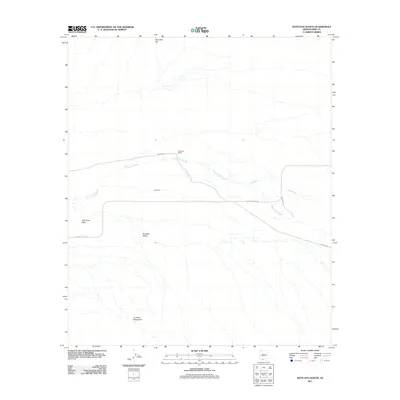
2011 Map of Kots Kug Ranch
USGS Topo · Published 2011About this map
Kots Kug Ranch sits within a landscape defined by seasonal watercourses and desert basins in the Chukut Kuk District. This 2011 survey illustrates the sparse settlement patterns typical of this portion of Pima County, with the small community of Kots Kug serving as a central point of interest. The terrain is characterized by the expansive expanse of The Great Plain and the Tecolote Valley, bounded to the north by Chiweton Hill and to the south by the La Lesna Mountains. Transportation across this arid environment is facilitated by Papago Farms Rd and Indian Rte-2, which traverse the desert floor near the winding paths of Chukut Kuk Wash and Big Wash. These washes dictate the drainage patterns of the region, emphasizing the importance of natural topography in an area where developed infrastructure remains minimal.
Find a feature on this map
10 named features on this map. Tap any name to fly to it.
Don’t see what you’re looking for? This feature index may not catch every label — zoom into the map to look around manually.
Map Details
Editions of this 2011 Kots Kug Ranch Map
This is the sole edition of this map. No revisions or reprints were ever made.
Other maps of this area

1954 · Sonoyta
USGS Topo · 1:250,000

1963 · Kom Vo
USGS Topo · 1:62,500

1963 · Gu Oidak
USGS Topo · 1:62,500
1963 · La Lesna Mts.
USGS Topo · 1:62,500

1963 · Lukeville
USGS Topo · 1:250,000
1988 · Chukut Kuk
USGS Topo · 1:24,000
1988 · Kom Vo
USGS Topo · 1:24,000
1988 · Gu Oidak
USGS Topo · 1:24,000
1988 · Tecolote Ranch
USGS Topo · 1:24,000
1988 · Kupk
USGS Topo · 1:24,000