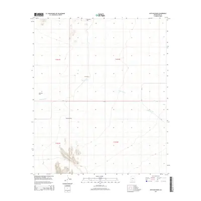
2014 Map of Kots Kug Ranch
USGS Topo · Published 2014About this map
Kots Kug Ranch sits within a high desert landscape characterized by broad alluvial features and isolated peaks in the Chukut Kuk District. The terrain is defined by the expansive Great Plain to the west and the Tecolote Valley in the south-central portion of the quadrangle. Drainage patterns are dominated by the Chukut Kuk Wash, which meanders across the center of the sheet, and the Big Wash appearing in the eastern sections. Elevated landmarks like Chiweton Hill provide relief against the low-lying washes. Infrastructure is primarily limited to Bureau of Indian Affairs routes, including Bia-20, Bia-21, and Bia-2, which facilitate movement through this cattle-ranching and conservation landscape during the early 21st century.
Find a feature on this map
13 named features on this map. Tap any name to fly to it.
Don’t see what you’re looking for? This feature index may not catch every label — zoom into the map to look around manually.
Map Details
Editions of this 2014 Kots Kug Ranch Map
This is the sole edition of this map. No revisions or reprints were ever made.
Other maps of this area

1954 · Sonoyta
USGS Topo · 1:250,000

1963 · Kom Vo
USGS Topo · 1:62,500

1963 · Gu Oidak
USGS Topo · 1:62,500
1963 · La Lesna Mts.
USGS Topo · 1:62,500

1963 · Lukeville
USGS Topo · 1:250,000
1988 · Chukut Kuk
USGS Topo · 1:24,000
1988 · Kom Vo
USGS Topo · 1:24,000
1988 · Gu Oidak
USGS Topo · 1:24,000
1988 · Tecolote Ranch
USGS Topo · 1:24,000
1988 · Kupk
USGS Topo · 1:24,000