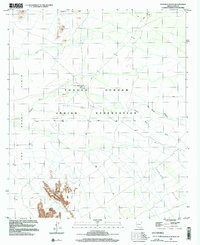
1996 Map of Kots Kug Ranch
USGS Topo · Published 2002About this map
Kots Kug Ranch sits at the heart of this desert landscape, a remote outpost within the Tohono O'odham Indian Reservation during the late twentieth century. The terrain is defined by dramatic elevation changes, rising from the broad expanse of The Great Plain in the west to the prominent peaks of the La Lesna Mountains in the south and Chiweton Hill to the north. Water management in this arid environment is evident through the network of ephemeral drainages, including Chukut Kuk Wash and Big Chukut Kuk Wash, which carve through the landscape toward the Tecolote Valley. A small Cemetery near the ranch house provides a point of interest for genealogists and local historians, marking a permanent human presence in an area largely characterized by open range and unimproved roads.
Find a feature on this map
11 named features on this map. Tap any name to fly to it.
Don’t see what you’re looking for? This feature index may not catch every label — zoom into the map to look around manually.
Map Details
Editions of this 1996 Kots Kug Ranch Map
This is the sole edition of this map. No revisions or reprints were ever made.
Other maps of this area

1954 · Sonoyta
USGS Topo · 1:250,000

1963 · Kom Vo
USGS Topo · 1:62,500

1963 · Gu Oidak
USGS Topo · 1:62,500
1963 · La Lesna Mts.
USGS Topo · 1:62,500

1963 · Lukeville
USGS Topo · 1:250,000
1988 · Chukut Kuk
USGS Topo · 1:24,000
1988 · Kom Vo
USGS Topo · 1:24,000
1988 · Gu Oidak
USGS Topo · 1:24,000
1988 · Tecolote Ranch
USGS Topo · 1:24,000
1988 · Kupk
USGS Topo · 1:24,000