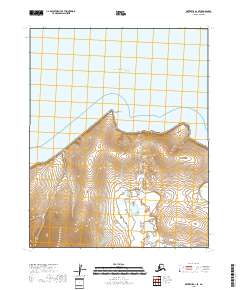
2018 Map of Kotzebue A-1 SE
USGS Topo · Published 2018About this map
Motherwood Point stands as a prominent northern projection along the coastline of the Kotzebue Sound in this 2018 coastal survey. The map details the transition from the marine environment of Spafarief Bay to a complex interior terrain defined by steep drainage systems. Small waterways such as Alder Cr and Kirk Cr carve through the land, illustrating the hydrological patterns of the Northwest Arctic region. The absence of roads or established settlements emphasizes the character of this landscape, where natural features like the coastal points and creek systems are the primary markers of location within the Public Land Survey System townships of T8N R17W and T7N R16W.
Find a feature on this map
9 named features on this map. Tap any name to fly to it.
Don’t see what you’re looking for? This feature index may not catch every label — zoom into the map to look around manually.
Map Details
Editions of this 2018 Kotzebue A-1 SE Map
This is the sole edition of this map. No revisions or reprints were ever made.
Other maps of this area

1950 · Kotzebue A-1
USGS Topo · 1:63,360

1950 · Bendeleben
USGS Topo · 1:250,000

1950 · Bendeleben D-1
USGS Topo · 1:63,360

1951 · Candle
USGS Topo · 1:250,000

1951 · Selawik
USGS Topo · 1:250,000

1951 · Bendeleben
USGS Topo · 1:250,000

1951 · Kotzebue
USGS Topo · 1:250,000

1951 · Candle D-6
USGS Topo · 1:63,360

1951 · Selawik A-6
USGS Topo · 1:63,360

1955 · Candle
USGS Topo · 1:250,000