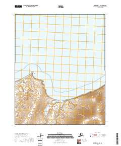
2018 Map of Kotzebue A-1 SW
USGS Topo · Published 2018About this map
Kotzebue Sound dominates the northern expanse of this 2018 coastal study, meeting the shoreline at the prominent geographic marker of Ninemile Point. The landscape transitions from the open waters of the sound into the sheltered indentation of Willow Bay, where the drainage of Willow Creek and Camp Creek meet the sea. The interior terrain is defined by dramatic elevation changes rising from the coastline, a characteristic of the Northwest Arctic's shoreline. This map provides a precise view of the hydrology and coastal topography before the effects of more recent erosion and climate shifts significantly alter the reach of the sound into the mouth of Willow Creek.
Find a feature on this map
11 named features on this map. Tap any name to fly to it.
Don’t see what you’re looking for? This feature index may not catch every label — zoom into the map to look around manually.
Map Details
Editions of this 2018 Kotzebue A-1 SW Map
This is the sole edition of this map. No revisions or reprints were ever made.
Other maps of this area

1950 · Kotzebue A-1
USGS Topo · 1:63,360

1950 · Bendeleben D-2
USGS Topo · 1:63,360

1950 · Bendeleben
USGS Topo · 1:250,000

1950 · Bendeleben D-1
USGS Topo · 1:63,360

1950 · Kotzebue A-2
USGS Topo · 1:63,360

1951 · Bendeleben
USGS Topo · 1:250,000

1951 · Kotzebue
USGS Topo · 1:250,000

1958 · Kotzebue
USGS Topo · 1:250,000

1964 · Bendeleben
USGS Topo · 1:250,000

1964 · Kotzebue
USGS Topo · 1:250,000