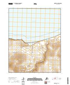
2018 Map of Kotzebue A-3 SE
USGS Topo · Published 2018About this map
Sullivan Bluffs command the coastline where the tundra meets the expansive Kotzebue Sound in this northern Alaskan landscape. The coastal terrain transition is marked by the sheltered Sullivan Lake and the drainage of Sullivan Cr, which flows north toward the shoreline. Much of the southern portion of this area is protected within the Bering Land Bridge National Preserve, reflecting a wilderness preserved for its geological and cultural significance to the history of human migration. Further inland, the terrain is defined by the winding course of Mystic Cr and a series of low-lying hills and wetlands. This 2018 survey captures the natural state of the Seward Peninsula's northern edge, a place defined by its hydrology and proximity to the Chukchi Sea.
Find a feature on this map
10 named features on this map. Tap any name to fly to it.
Don’t see what you’re looking for? This feature index may not catch every label — zoom into the map to look around manually.
Map Details
Editions of this 2018 Kotzebue A-3 SE Map
This is the sole edition of this map. No revisions or reprints were ever made.
Other maps of this area

1950 · Bendeleben D-2
USGS Topo · 1:63,360

1950 · Bendeleben
USGS Topo · 1:250,000

1950 · Bendeleben D-3
USGS Topo · 1:63,360

1950 · Kotzebue A-3
USGS Topo · 1:63,360

1950 · Kotzebue A-2
USGS Topo · 1:63,360

1951 · Bendeleben
USGS Topo · 1:250,000

1951 · Kotzebue
USGS Topo · 1:250,000

1958 · Kotzebue
USGS Topo · 1:250,000

1964 · Bendeleben
USGS Topo · 1:250,000

1964 · Kotzebue
USGS Topo · 1:250,000