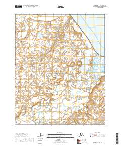
2019 Map of Kotzebue A-4 SW
USGS Topo · Published 2019About this map
Bering Land Bridge National Preserve encompasses the majority of this coastal Arctic landscape, where the tundra meets the saltwater of Kotzebue Sound. The terrain is defined by a dense network of thaw lakes and wetlands, characteristic of the Seward Peninsula's permafrost environment. The Goodhope River meanders across the southern and eastern portions of the quadrangle, serving as a primary hydrologic artery alongside smaller tributaries like Eagle Cr and Pot Cr. This 2019 survey by the U.S. Geological Survey illustrates a wilderness preserved in its natural state, devoid of permanent settlements or modern road infrastructure, emphasizing the remote character of the Northwest Arctic Borough. The intricate contouring and wetland symbology provide a detailed record of the shifting coastal plains and riparian corridors as they appeared in the early 21st century.
Find a feature on this map
9 named features on this map. Tap any name to fly to it.
Don’t see what you’re looking for? This feature index may not catch every label — zoom into the map to look around manually.
Map Details
Editions of this 2019 Kotzebue A-4 SW Map
This is the sole edition of this map. No revisions or reprints were ever made.
Other maps of this area

1950 · Bendeleben D-5
USGS Topo · 1:63,360

1950 · Bendeleben
USGS Topo · 1:250,000

1950 · Bendeleben D-4
USGS Topo · 1:63,360

1950 · Kotzebue A-4
USGS Topo · 1:63,360

1950 · Kotzebue A-5
USGS Topo · 1:63,360

1951 · Bendeleben
USGS Topo · 1:250,000

1951 · Kotzebue
USGS Topo · 1:250,000

1958 · Kotzebue
USGS Topo · 1:250,000

1964 · Bendeleben
USGS Topo · 1:250,000

1964 · Kotzebue
USGS Topo · 1:250,000