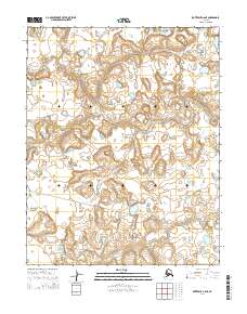
2014 Map of Kotzebue A-6 NE
USGS Topo · Published 2014About this map
The Bering Land Bridge National Preserve dominates this section of the Seward Peninsula, protecting a landscape that was once part of the massive terrestrial link between Asia and North America. The Nugnugaluktuk River meanders across the northern and central portions of the quadrangle, carving a path through terrain defined by its intricate hydrography and varying elevations. Human presence in this remote landscape is represented by the Lane River Road, which traverses the southern portion of the survey area. This 2014 edition reflects modern mapping efforts by the U.S. Geological Survey and the Alaska Dept. of Transportation, providing a clear look at the township and range boundaries including t10n r28w and t9n r28w.
Find a feature on this map
9 named features on this map. Tap any name to fly to it.
Don’t see what you’re looking for? This feature index may not catch every label — zoom into the map to look around manually.
Map Details
Editions of this 2014 Kotzebue A-6 NE Map
This is the sole edition of this map. No revisions or reprints were ever made.
Other maps of this area

1950 · Kotzebue A-6
USGS Topo · 1:63,360

1950 · Kotzebue B-5
USGS Topo · 1:63,360

1950 · Kotzebue B-6
USGS Topo · 1:63,360

1950 · Kotzebue A-5
USGS Topo · 1:63,360

1951 · Kotzebue
USGS Topo · 1:250,000

1958 · Kotzebue
USGS Topo · 1:250,000

1964 · Kotzebue
USGS Topo · 1:250,000
2014 · Kotzebue A-6 SE
USGS Topo · 1:25,000
2014 · Kotzebue A-5 SW
USGS Topo · 1:25,000
2014 · Kotzebue B-5 SW
USGS Topo · 1:25,000