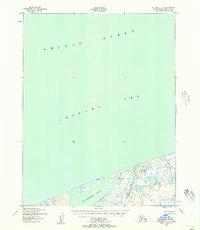
1950 Map of Kotzebue C-6
USGS Topo · Published 1957About this map
The vast reaches of the Arctic Ocean and the Chukchi Sea dominate the seascape in this mid-century mapping of the Alaska coast. While the northern portion of the sheet is entirely open water, the southern margin reveals a complex coastal landscape where the Shishmaref Inlet meets the shore. The land is characterized by a low-lying, wetland-heavy environment, punctuated by the Kalik River as it winds toward the inlet. Small coastal settlements such as Kividlo and Singyak are documented here, providing critical evidence of seasonal or permanent habitation along the remote shoreline during the early 1950s. The topographic detail, derived from aerial photography by the Army Map Service, captures the intricate shoreline and scattered ponds of the Seward Peninsula's northern coast before significant modern environmental changes.
Find a feature on this map
6 named features on this map. Tap any name to fly to it.
Don’t see what you’re looking for? This feature index may not catch every label — zoom into the map to look around manually.
Map Details
Editions of this 1950 Kotzebue C-6 Map
3 editions found
Other maps of this area

1950 · Kotzebue C-6
USGS Topo · 1:63,360

1950 · Shishmaref
USGS Topo · 1:250,000
1950 · Kotzebue C-5
USGS Topo · 1:63,360

1950 · Shishmaref B-1
USGS Topo · 1:63,360

1950 · Kotzebue B-5
USGS Topo · 1:63,360

1950 · Kotzebue B-6
USGS Topo · 1:63,360

1951 · Shishmaref
USGS Topo · 1:250,000

1951 · Kotzebue
USGS Topo · 1:250,000

1958 · Kotzebue
USGS Topo · 1:250,000

1964 · Kotzebue
USGS Topo · 1:250,000