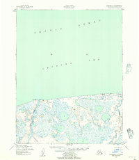
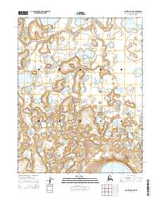
1950 Map of Kotzebue C-5
USGS Topo · Published 1957About this map
The Arctic Ocean shoreline and the waters of the Chukchi Sea dominate this mid-century topographic study of the Alaskan coastline. The landscape is characterized by a complex network of coastal wetlands and thermokarst lakes, where the Kitluk River and Espenberg River wind toward the sea. Mapping efforts by the Army Map Service relied on aerial photography from 1949 and 1950 to document this ever-shifting littoral zone. Navigation and surveying landmarks are the primary human markers on this map, including the Northwest Corner Light and various triangulation stations like Vabm Kittluk 81. The intricate shoreline detail reflects the approximate line of mean high water, providing a record of the coastal geometry before decades of Arctic shoreline erosion and permafrost changes reshaped these drainage patterns.
Find a feature on this map
9 named features on this map. Tap any name to fly to it.
Don’t see what you’re looking for? This feature index may not catch every label — zoom into the map to look around manually.
Map Details
Editions of this 1950 Kotzebue C-5 Map
2 editions found
Other maps of this area

1950 · Kotzebue C-6
USGS Topo · 1:63,360

1950 · Kotzebue B-4
USGS Topo · 1:63,360

1950 · Kotzebue B-5
USGS Topo · 1:63,360
1950 · Kotzebue C-4
USGS Topo · 1:63,360

1950 · Kotzebue B-6
USGS Topo · 1:63,360

1951 · Kotzebue
USGS Topo · 1:250,000

1958 · Kotzebue
USGS Topo · 1:250,000

1964 · Kotzebue
USGS Topo · 1:250,000
2014 · Kotzebue B-6 NE
USGS Topo · 1:25,000
2014 · Kotzebue B-5 NE
USGS Topo · 1:25,000