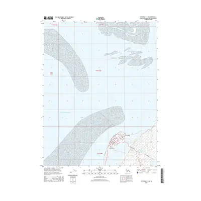
2016 Map of Kotzebue D-2 NE
USGS Topo · Published 2016About this map
Kotzebue serves as the focal point of this coastal survey, situated on the Baldwin Peninsula where the land meets the expansive Kotzebue Sound. The town's grid is clearly defined, with major thoroughfares like Shore Avenue, Second Avenue, and Ted Stevens Way connecting the community to vital infrastructure. The presence of the Ralph Wien Memorial Airport and Fishing Camp Road highlights the area's dual reliance on modern aviation and traditional subsistence activities. To the south of the settlement, the Kotzebue Cem and the waters of Vortac Lake provide localized landmarks within the tundra landscape. This document captures the footprint of the region's largest hub as it appeared in the mid-2010s, showing the intersection of local roads and the untamed coastal environment.
Find a feature on this map
20 named features on this map. Tap any name to fly to it.
Don’t see what you’re looking for? This feature index may not catch every label — zoom into the map to look around manually.
Map Details
Editions of this 2016 Kotzebue D-2 NE Map
This is the sole edition of this map. No revisions or reprints were ever made.
Other maps of this area

1951 · Noatak
USGS Topo · 1:250,000

1951 · Kotzebue
USGS Topo · 1:250,000

1951 · Kotzebue D-1
USGS Topo · 1:63,360

1951 · Kotzebue D-2
USGS Topo · 1:63,360

1955 · Noatak
USGS Topo · 1:250,000
1955 · Noatak A-1
USGS Topo · 1:63,360
1955 · Noatak A-2
USGS Topo · 1:63,360

1958 · Kotzebue
USGS Topo · 1:250,000

1964 · Noatak
USGS Topo · 1:250,000

1964 · Kotzebue
USGS Topo · 1:250,000