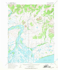
1955 Map of Noatak A-1
USGS Topo · Published 1970About this map
The Noatak River dominates this mid-century subarctic landscape as it winds through a complex network of braided channels and marshes before reaching Hotham Inlet. Evidence of seasonal habitation and subsistence land use is visible in the presence of Cabins near the riverbank and a Reindeer Corral positioned between the river and the Mulik Hills. This area, mapped from aerial photography in the early 1950s, reveals a terrain defined by the transition from the high elevations of the Igichuk Hills to the saturated lowlands of Kinuk Island. A Winter Trail provides a overland connection through the marshy interior, while features like the Little Noatak Slough and Shiliak Creek illustrate the shifting hydrology of the delta. The proximity of the corral and cabins to the river's edge highlights the importance of the waterway for both transportation and the regional reindeer herding economy of the era.
Find a feature on this map
13 named features on this map. Tap any name to fly to it.
Don’t see what you’re looking for? This feature index may not catch every label — zoom into the map to look around manually.
Map Details
Editions of this 1955 Noatak A-1 Map
This is the sole edition of this map. No revisions or reprints were ever made.
Other maps of this area

1951 · Baird Mountains
USGS Topo · 1:250,000

1951 · Selawik
USGS Topo · 1:250,000

1951 · Noatak
USGS Topo · 1:250,000

1951 · Kotzebue
USGS Topo · 1:250,000

1951 · Kotzebue D-1
USGS Topo · 1:63,360

1951 · Kotzebue D-2
USGS Topo · 1:63,360

1951 · Selawik D-6
USGS Topo · 1:63,360

1952 · Selawik D-6
USGS Topo · 1:63,360

1955 · Noatak
USGS Topo · 1:250,000
1955 · Baird Mountains A-6
USGS Topo · 1:63,360