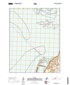
2019 Map of Kotzebue D-2 NE
USGS Topo · Published 2019About this map
Kotzebue occupies the tip of the Baldwin Peninsula on this 2019 survey, serving as a vital regional hub for the Northwest Arctic. The settlement layout reflects its reliance on aviation and coastal access, anchored by the Ralph Wien Memorial Airport and a grid of streets including Shore Avenue and Lagoon St. Education and community services are represented by the Univ of Alaska Fairbanks Chukchi Campus and the Kotzebue Cem, highlighting the town's role as a center for higher learning and local heritage.
Find a feature on this map
19 named features on this map. Tap any name to fly to it.
Don’t see what you’re looking for? This feature index may not catch every label — zoom into the map to look around manually.
Map Details
Editions of this 2019 Kotzebue D-2 NE Map
This is the sole edition of this map. No revisions or reprints were ever made.
Other maps of this area

1951 · Noatak
USGS Topo · 1:250,000

1951 · Kotzebue
USGS Topo · 1:250,000

1951 · Kotzebue D-1
USGS Topo · 1:63,360

1951 · Kotzebue D-2
USGS Topo · 1:63,360

1955 · Noatak
USGS Topo · 1:250,000
1955 · Noatak A-1
USGS Topo · 1:63,360
1955 · Noatak A-2
USGS Topo · 1:63,360

1958 · Kotzebue
USGS Topo · 1:250,000

1964 · Noatak
USGS Topo · 1:250,000

1964 · Kotzebue
USGS Topo · 1:250,000