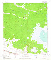
1962 Map of Kraemer
USGS Topo · Published 1963About this map
Rathborne Swamp dominates the center of this landscape, a vast wetland matrix defined by a labyrinth of waterways including Bayou Grand and Bayou L'Ours. In the early 1960s, the northern settlement of Kraemer and the southern clusters near Ewing and Rousseau represent the primary residential hubs, while large agricultural holdings like Webster Plantation and Melodia Plantation mark the transition toward the cultivated lands along Bayou Lafourche. The era's industrial footprint is visible through numerous Gas Wells and Oil Wells scattered through the swamp, alongside infrastructure such as the Southern Pacific railroad line and the Halpin road. Education and community life are anchored by the Choctaw Sch and St Charles Sch, while the shoreline of Lake Boeuf provides a natural eastern boundary to the extensive marshlands and spoil banks of Lafourche Parish.
Find a feature on this map
41 named features on this map. Tap any name to fly to it.
Don’t see what you’re looking for? This feature index may not catch every label — zoom into the map to look around manually.
Map Details
Editions of this 1962 Kraemer Map
4 editions found
Other maps of this area

1892 · Lac Des Allemands
USGS Topo · 1:62,500

1892 · Gibson
USGS Topo · 1:62,500

1892 · Houma
USGS Topo · 1:62,500

1892 · Thibodaux
USGS Topo · 1:62,500

1897 · Gibson
USGS Topo · 1:62,500

1932 · Lac Des Allemands NW
USGS Topo · 1:31,680

1932 · Lac Des Allemands SE
USGS Topo · 1:31,680

1932 · Lac Des Allemands SW
USGS Topo · 1:31,680

1932 · Houma NE
USGS Topo · 1:31,680

1932 · Thibodaux NE
USGS Topo · 1:31,680