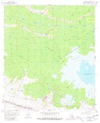
1962 Map of Kraemer
USGS Topo · Published 1981About this map
Kraemer and its surrounding wetlands are the centerpiece of this coastal Louisiana survey, which documents a landscape defined by water and heavy industry during the early 1960s. The community of Kraemer sits at the northern edge of the sheet, where Bayou L'Ours and Bayou Grand wind through the dense forest. Further south, the vast Rathborne Swamp gives way to the open waters of Lake Boeuf, a significant landmark for local navigation and drainage.
Find a feature on this map
35 named features on this map. Tap any name to fly to it.
Don’t see what you’re looking for? This feature index may not catch every label — zoom into the map to look around manually.
Map Details
Editions of this 1962 Kraemer Map
4 editions found
Other maps of this area

1892 · Lac Des Allemands
USGS Topo · 1:62,500

1892 · Gibson
USGS Topo · 1:62,500

1892 · Houma
USGS Topo · 1:62,500

1892 · Thibodaux
USGS Topo · 1:62,500

1897 · Gibson
USGS Topo · 1:62,500

1932 · Lac Des Allemands NW
USGS Topo · 1:31,680

1932 · Lac Des Allemands SE
USGS Topo · 1:31,680

1932 · Lac Des Allemands SW
USGS Topo · 1:31,680

1932 · Houma NE
USGS Topo · 1:31,680

1932 · Thibodaux NE
USGS Topo · 1:31,680