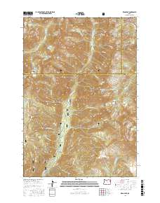
2017 Map of Krag Peak
USGS Topo · Published 2017About this map
Whitman National Forest and Wallowa National Forest converge in this high-altitude landscape of the Eagle Cap Wilderness area. The terrain is defined by dramatic geologic formations like the Granite Cliff and the narrow passage known as The Box, where the E Fork Eagle Cr carves through the mountains. Numerous alpine water bodies are scattered across the peaks, including Lookingglass Lake, Two Color Lake, and Pine Lakes. The area is bisected by the Union and Baker County line, following the high ridges between Hummingbird Mtn and Krag Peak. E Eagle Rd provides the primary access route into the southern portion of the quadrangle, following the course of Eagle Cr, while higher elevations remain accessible only by trail, preserving the remote character of Truax Mtn and Granite Mtn.
Find a feature on this map
43 named features on this map. Tap any name to fly to it.
Don’t see what you’re looking for? This feature index may not catch every label — zoom into the map to look around manually.
Map Details
Editions of this 2017 Krag Peak Map
This is the sole edition of this map. No revisions or reprints were ever made.
Other maps of this area

1915 · Pine
USGS Topo · 1:125,000

1954 · Cornucopia
USGS Topo · 1:62,500

1954 · Eagle Cap
USGS Topo · 1:62,500

1955 · Baker
USGS Topo · 1:250,000

1955 · Grangeville
USGS Topo · 1:250,000

1957 · Halfway
USGS Topo · 1:62,500

1957 · Sparta
USGS Topo · 1:62,500

1959 · Baker
USGS Topo · 1:250,000

1959 · Grangeville
USGS Topo · 1:250,000

1981 · Baker
USGS Topo · 1:100,000