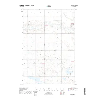
2017 Map of Kreiser Lake
USGS Topo · Published 2017About this map
Wild Rice River meanders across this Richland County landscape, defining the topography of a region dominated by glacial prairie potholes and rural section lines. The northern half of the survey is characterized by the river's winding path and its tributary, Elk Creek, which passes near the Elk Creek Cem. The southern portion shifts toward a dense network of wetlands and small water bodies, including Kreiser Lake and Silver Lake. Small-scale aviation markers like the Thompson Private Airport and Krause Private Airport suggest the vast distances and specialized infrastructure of modern North Dakota farming life. The section-line road system, including routes like Co RD 16 and 87th St SE, maintains a rigid grid over the organic curves of the river valley, illustrating the intersection of late-20th-century land management with the area's natural hydrology.
Find a feature on this map
21 named features on this map. Tap any name to fly to it.
Don’t see what you’re looking for? This feature index may not catch every label — zoom into the map to look around manually.
Map Details
Editions of this 2017 Kreiser Lake Map
This is the sole edition of this map. No revisions or reprints were ever made.
Other maps of this area

1907 · Wyndmere
USGS Topo · 1:125,000

1953 · Fargo
USGS Topo · 1:250,000

1956 · Fargo
USGS Topo · 1:250,000

1958 · Hamlin
USGS Topo · 1:24,000

1958 · Geneseo
USGS Topo · 1:24,000

1960 · Wyndmere
USGS Topo · 1:24,000

1960 · Wyndmere SE
USGS Topo · 1:24,000

1960 · De Lamere
USGS Topo · 1:24,000

1964 · Kreiser Lake
USGS Topo · 1:24,000

1964 · Moselle
USGS Topo · 1:24,000
Featured Places
- Dexter Township, ND
- Wyndmere Township, ND
- Liberty Grove Township, ND
- Danton Township, ND
- Richland County, ND