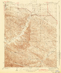
1941 Map of Kreyenhagen Hills
USGS Topo · Published 1941About this map
Pleasant Valley opens into a landscape of deep canyons and prominent ridges in this 1930s-era survey of western Fresno County. The terrain is dominated by the Kreyenhagen Hills, where established cattle and sheep operations like Zuburi Ranch, Camino Ranch, and Kreyenhagen Ranch were situated among the draws. The settlement of Alcalde sits at the mouth of Alcalde Canyon, serving as a gateway where the upland drainage of Waltham Creek meets the flatter valley floor. Evidence of the early automotive era is visible in the layout of the Coalinga Road and Bakersfield Road, which provided essential links for the remote ranching outposts such as Esrey Ranch and Zapato. This detailed topography traces the complex network of seasonal watercourses, including Jacalitos Creek and Garcia Canyon, which shaped the movement of people and livestock through the hills.
Find a feature on this map
23 named features on this map. Tap any name to fly to it.
Don’t see what you’re looking for? This feature index may not catch every label — zoom into the map to look around manually.
Map Details
Editions of this 1941 Kreyenhagen Hills Map
2 editions found
Other maps of this area

1912 · Coalinga
USGS Topo · 1:125,000

1914 · Cholame
USGS Topo · 1:125,000

1915 · Cholame
USGS Topo · 1:125,000

1917 · Cholame
USGS Topo · 1:125,000

1930 · Canoas Creek
USGS Topo · 1:31,680

1933 · Guijarral Hills
USGS Topo · 1:31,680

1934 · The Dark Hole
USGS Topo · 1:31,680

1934 · Reef Ridge
USGS Topo · 1:31,680

1934 · Canoas Creek
USGS Topo · 1:31,680

1936 · Kreyenhagen Hills
USGS Topo · 1:31,680