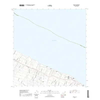
2017 Map of Kukaiau
USGS Topo · Published 2017About this map
Island of Hawai‘i’s Hamakua Coast is defined by a dense network of steep drainages cutting toward the Pacific Ocean, as seen in this 2017 topographic study. The settlement pattern clusters along the lower elevations where the Hawaii Belt Rd and the Old Mamalahoa Hwy traverse the landscape. Historical residential pockets like Kūka‘iau, Milo Village, Kukui Village, and Niu Village sit between deep gulches such as Ka‘awikiwiki Gulch and Kealakaha Stream. The coastal geography is marked by prominent headlands including Popoloau Point and Nahiwa Point. Rising toward the interior, the terrain transitions toward ranching lands accessed via Mauna Kea Ranch Rd, while the steep descent of the watercourses is punctuated by features like Hikiau Falls.
Find a feature on this map
44 named features on this map. Tap any name to fly to it.
Don’t see what you’re looking for? This feature index may not catch every label — zoom into the map to look around manually.
Map Details
Editions of this 2017 Kukaiau Map
This is the sole edition of this map. No revisions or reprints were ever made.
Other maps of this area

1915 · Hamakua
USGS Topo · 1:62,500

1915 · Honomu
USGS Topo · 1:62,500

1954 · Hawaii North
USGS Topo · 1:250,000

1956 · Keanakolu
USGS Topo · 1:24,000

1956 · Umikoa
USGS Topo · 1:24,000

1957 · Kukaiau
USGS Topo · 1:24,000

1957 · Honokaa
USGS Topo · 1:24,000

1959 · Hawaii North
USGS Topo · 1:250,000

1961 · Hawaii North
USGS Topo · 1:250,000
1966 · Papaaloa
USGS Topo · 1:24,000