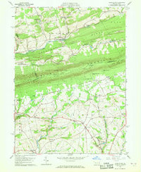
1960 Map of Kunkletown
USGS Topo · Published 1968About this map
The Blue Mountain ridge dominates the center of this landscape, creating a physical divide between the settlements of Kunkletown and the southern valley floors. Along the slopes of Chestnut Ridge, the landscape shows evidence of local industry through several claypits and settling basins near Aquashicola Creek. The Appalachian Trail traces the high crest of the mountain, marking a transition between the northern woods and the agrarian patterns of Moore township to the south. Local community life is anchored by landmarks like St Matthews Ch and Christ Ch, while the settlement at Chapman sits at a lower elevation near several quarries. The map documents a period of early suburban development seen in Kingswood Estates, juxtaposed against the established rural crossroads of Point Phillip and Klecknersville.
Find a feature on this map
52 named features on this map. Tap any name to fly to it.
Don’t see what you’re looking for? This feature index may not catch every label — zoom into the map to look around manually.
Map Details
Editions of this 1960 Kunkletown Map
3 editions found
Other maps of this area

1894 · Allentown
USGS Topo · 1:62,500

1902 · Slatington
USGS Topo · 1:62,500

1914 · Wind Gap
USGS Topo · 1:62,500

1916 · Wind Gap
USGS Topo · 1:62,500

1922 · Mauch Chunk
USGS Topo · 1:62,500

1924 · Mauch Chunk
USGS Topo · 1:62,500

1937 · Allentown West
USGS Topo · 1:48,000

1939 · Allentown
USGS Topo · 1:62,500

1942 · Allentown West
USGS Topo · 1:62,500

1943 · Mauch Chunk
USGS Topo · 1:62,500
Featured Places
- Chapman, Moore Township
- Eldred Township, PA
- Lehigh Township, PA
- Crossroads, Moore Township
- Moore Township, PA