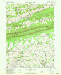
1960 Map of Kunkletown
USGS Topo · Published 1972About this map
Chestnut Ridge and Blue Mountain define the sharp topographic grain of this Northampton County landscape, where the Appalachian Trail follows the high ridgeline through State Game Lands No 168. Below the ridges, the agrarian and industrial character of the 1960s is evident in the cluster of settlements including Kunkletown, Klecknersville, and Emanuelsville. The map captures an era of infrastructure change, showing several abandoned railroad grades that once served the local economy, alongside active quarries and claypits near Smith Gap. Local history is anchored by numerous rural congregations such as St Matthews Ch and Zion Ch, while the southern portion of the quadrangle is drained by the meandering Hokendauqua Creek and Monocacy Creek. Recent suburban growth is signaled by the inclusion of Kingswood Estates and a Trailer Park, added during 1970 revisions.
Find a feature on this map
51 named features on this map. Tap any name to fly to it.
Don’t see what you’re looking for? This feature index may not catch every label — zoom into the map to look around manually.
Map Details
Editions of this 1960 Kunkletown Map
3 editions found
Other maps of this area

1894 · Allentown
USGS Topo · 1:62,500

1902 · Slatington
USGS Topo · 1:62,500

1914 · Wind Gap
USGS Topo · 1:62,500

1916 · Wind Gap
USGS Topo · 1:62,500

1922 · Mauch Chunk
USGS Topo · 1:62,500

1924 · Mauch Chunk
USGS Topo · 1:62,500

1937 · Allentown West
USGS Topo · 1:48,000

1939 · Allentown
USGS Topo · 1:62,500

1942 · Allentown West
USGS Topo · 1:62,500

1943 · Mauch Chunk
USGS Topo · 1:62,500
Featured Places
- Chapman, Moore Township
- Eldred Township, PA
- Lehigh Township, PA
- Crossroads, Moore Township
- Moore Township, PA