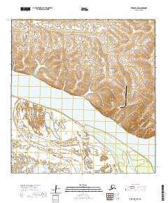
2020 Map of Kwiguk A-3 SW
USGS Topo · Published 2020About this map
St. Mary's and Pitkas Point stand as the primary settlements in this region of the Yukon River delta, where the river's massive braids and the Driftwood Slough dominate the landscape. The geography is defined by the confluence of major waterways, including the Andreafsky River and the Nantok River, which navigate a complex network of wetlands. Rising above the flat river plains, Andreafsky Mtn provides a rare topographical landmark in a terrain otherwise characterized by shifting water channels and seasonal silt deposits. Infrastructure is concentrated near the settlements, featuring St Mary's Airport and the Saint Marys/Mountain Village Road, which provides a vital overland link in a territory where the river traditionally serves as the primary highway. The presence of the Pitkas Point Road and Yukon River Access points highlights the ongoing importance of subsistence and transport along the water's edge.
Find a feature on this map
21 named features on this map. Tap any name to fly to it.
Don’t see what you’re looking for? This feature index may not catch every label — zoom into the map to look around manually.
Map Details
Editions of this 2020 Kwiguk A-3 SW Map
This is the sole edition of this map. No revisions or reprints were ever made.
Other maps of this area

1951 · Marshall
USGS Topo · 1:250,000

1952 · Kwiguk
USGS Topo · 1:250,000

1952 · Kwiguk A-4
USGS Topo · 1:63,360

1952 · Kwiguk A-3
USGS Topo · 1:63,360

1952 · Marshall D-5
USGS Topo · 1:63,360

1952 · Marshall D-4
USGS Topo · 1:63,360

1954 · Marshall
USGS Topo · 1:250,000
2020 · Marshall D-4 NW
USGS Topo · 1:25,000
2020 · Marshall D-4 NE
USGS Topo · 1:25,000
2020 · Marshall D-5 NE
USGS Topo · 1:25,000