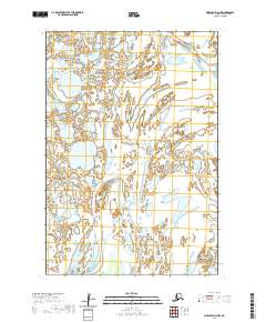
2020 Map of Marshall D-4 NW
USGS Topo · Published 2020About this map
The Kipungolak River and Nantok River dominate this portion of the Kusilvak Census Area, showcasing a landscape defined by an intricate network of waterways and wetlands. This 2020 U.S. Geological Survey topographic study illustrates the shifting, braided character of these subarctic river systems as they move through the vast alluvial plains. The Big River also traverses the eastern sections of the quadrangle, with its meandering path and numerous oxbow formations indicating a highly dynamic hydrologic environment. The lack of named settlements or man-made infrastructure on this sheet emphasizes the wilderness character of this region of Alaska, where the landscape is primarily organized by the Public Land Survey System boundaries such as t22n r77w and t21n r78w. For researchers, the map serves as a primary record of the hydrographic conditions of the late 2010s, capturing the specific alignment of riverbanks and sloughs before future seasonal cycles alter their courses.
Find a feature on this map
7 named features on this map. Tap any name to fly to it.
Don’t see what you’re looking for? This feature index may not catch every label — zoom into the map to look around manually.
Map Details
Editions of this 2020 Marshall D-4 NW Map
This is the sole edition of this map. No revisions or reprints were ever made.
Other maps of this area

1951 · Marshall
USGS Topo · 1:250,000

1952 · Kwiguk
USGS Topo · 1:250,000

1952 · Kwiguk A-4
USGS Topo · 1:63,360

1952 · Kwiguk A-3
USGS Topo · 1:63,360

1952 · Marshall D-5
USGS Topo · 1:63,360

1952 · Marshall D-4
USGS Topo · 1:63,360

1954 · Marshall
USGS Topo · 1:250,000
2020 · Marshall D-4 SE
USGS Topo · 1:25,000
2020 · Marshall D-5 SE
USGS Topo · 1:25,000
2020 · Marshall D-4 SW
USGS Topo · 1:25,000