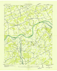
1935 Map of Kykers Ferry
USGS Topo · Published 1935About this map
The French Broad River and Little Pigeon River dominate this 1935 survey of the Sevier and Jefferson county borderlands, shortly after the Tennessee Valley Authority began its transformative work in the region. The landscape is defined by river-dependent transportation and small agricultural hamlets, most notably at Kykers Ferry, Hodges Ferry, and Stokley Ferry, which provided critical crossings before modern bridging. In Dumplin Valley, early industry is marked by Cooks Mill and Dumplin Mill, while the social fabric of the era is preserved in the locations of French Broad Academy and rural schoolhouses like Union Grove Sch and Bailey Sch. High-voltage infrastructure, including the North Carolina and Tennessee Transmission Line, already carves across the hills near Catlettsburg, signaling the technological shifts occurring in this pocket of the Tennessee Valley.
Find a feature on this map
58 named features on this map. Tap any name to fly to it.
Don’t see what you’re looking for? This feature index may not catch every label — zoom into the map to look around manually.
Map Details
Editions of this 1935 Kykers Ferry Map
This is the sole edition of this map. No revisions or reprints were ever made.
Other maps of this area

1883 · Morristown
USGS Topo · 1:125,000

1886 · Knoxville
USGS Topo · 1:125,000

1892 · Knoxville
USGS Topo · 1:125,000

1893 · Mt Guyot
USGS Topo · 1:125,000

1893 · Morristown
USGS Topo · 1:125,000

1894 · Knoxville
USGS Topo · 1:125,000

1895 · Morristown
USGS Topo · 1:125,000

1895 · Knoxville
USGS Topo · 1:125,000

1897 · Maynardville
USGS Topo · 1:125,000

1900 · Maynardville
USGS Topo · 1:125,000