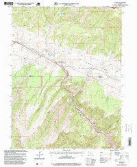
1996 Map of Kyune
USGS Topo · Published 1999About this map
Kyune sits at a critical transit juncture in Carbon County, where the Denver & Rio Grande Western RR follows the narrow corridor carved by the Price River. This mountainous landscape is defined by its industrial and recreational utility, showing a cluster of Mines, a Quarry, and multiple Gravel Pits that speak to the region's extraction history. The rugged topography is anchored by Indian Head and Beaver Ridge, with the steep Diamanti Canyon and Sulphur Canyon draining toward the river valley. The map also delineates the high-altitude boundary between the Ashley NF and the Price Canyon Recreation Area, illustrating how public lands are managed for both resource use and conservation. From the Communication Sites atop the ridges to the seasonal flow of Horse Creek, the map documents the infrastructure required to navigate and utilize this complex terrain in the late twentieth century.
Find a feature on this map
25 named features on this map. Tap any name to fly to it.
Don’t see what you’re looking for? This feature index may not catch every label — zoom into the map to look around manually.
Map Details
Editions of this 1996 Kyune Map
This is the sole edition of this map. No revisions or reprints were ever made.
Other maps of this area

1885 · Manti
USGS Topo · 1:250,000

1886 · Price River
USGS Topo · 1:250,000

1895 · Manti
USGS Topo · 1:250,000

1896 · Price River
USGS Topo · 1:250,000

1914 · Castle Gate
USGS Topo · 1:62,500

1916 · Castle Gate
USGS Topo · 1:62,500

1923 · Scofield
USGS Topo · 1:62,500

1925 · Scofield
USGS Topo · 1:62,500

1939 · Soldier Summit
USGS Topo · 1:62,500

1942 · Soldier Summit
USGS Topo · 1:62,500