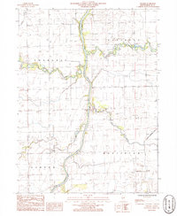
1986 Map of L'Erable
USGS Topo · Published 1986About this map
The Iroquois River winds prominently through this central Illinois landscape, serving as the primary drainage for a network of tributaries including Langan Creek, Beaver Creek, and Prairie Creek. The settlement of L'Erable sits south of the river, anchored by the L'Erable Cem, while the small community of Plato is positioned further southwest. This 1980s landscape is defined by the intersection of four distinct townships—Chebanse, Papineau, Ashkum, and Martinton—reflecting a traditional Midwestern agricultural grid.
Find a feature on this map
20 named features on this map. Tap any name to fly to it.
Don’t see what you’re looking for? This feature index may not catch every label — zoom into the map to look around manually.
Map Details
Editions of this 1986 L'Erable Map
This is the sole edition of this map. No revisions or reprints were ever made.
Other maps of this area

1922 · Momence
USGS Topo · 1:62,500

1922 · Kankakee
USGS Topo · 1:62,500

1924 · Momence
USGS Topo · 1:62,500

1924 · Kankakee
USGS Topo · 1:62,500

1935 · Watseka
USGS Topo · 1:48,000

1939 · Watseka
USGS Topo · 1:62,500

1944 · Gilman
USGS Topo · 1:62,500

1946 · Gilman
USGS Topo · 1:62,500

1953 · Chicago
USGS Topo · 1:250,000

1953 · Danville
USGS Topo · 1:250,000