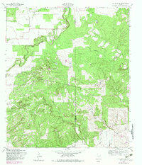
1958 Map of La Coste NE
USGS Topo · Published 1982About this map
Potranca Creek and Media Creek weave through this section of the Texas Hill Country, where the landscape transitions across the Medina and Bexar County line. Originally field checked in the late 1950s and updated with aerial data from 1979, the map reveals a rugged terrain dominated by drainage networks like Big Sous Creek and its tributary, East Branch Big Sous Creek.
Find a feature on this map
11 named features on this map. Tap any name to fly to it.
Don’t see what you’re looking for? This feature index may not catch every label — zoom into the map to look around manually.
Map Details
Editions of this 1958 La Coste NE Map
2 editions found
Other maps of this area

1953 · Culebra Hill
USGS Topo · 1:24,000

1953 · Macdona
USGS Topo · 1:24,000

1953 · Helotes
USGS Topo · 1:24,000

1954 · San Antonio
USGS Topo · 1:250,000

1956 · Medina Lake
USGS Topo · 1:62,500

1957 · San Antonio
USGS Topo · 1:250,000

1958 · La Coste
USGS Topo · 1:24,000

1958 · La Coste NE
USGS Topo · 1:24,000

1964 · Riomedina
USGS Topo · 1:24,000

1964 · Castroville
USGS Topo · 1:24,000