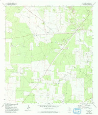
1972 Map of La Gloria
USGS Topo · Published 1993About this map
North Sun Oil Field and Strong Oil Field define the industrial landscape of this South Texas region, where petroleum infrastructure intersects with longstanding ranching tracts. The settlement of La Gloria serves as a local hub, featuring a Refinery and proximity to a Landing Strip. The map reveals a pattern of dispersed rural communities and family-named locales, including Santa Anna, Santa Catarina, and Robberson, alongside the Diamond O Ranch. For those researching regional genealogy, several burial sites are documented across the brushland, such as Tangue Allegre Cem, San Jose Cem, Santa Maria Cem, and Coyote Cem. The map's extensive network of pipelines, Oil Wells, and Pumping Stations underscores the economic transition of the early 1970s, as traditional ranching shared the land with an expanding energy sector.
Find a feature on this map
20 named features on this map. Tap any name to fly to it.
Don’t see what you’re looking for? This feature index may not catch every label — zoom into the map to look around manually.
Map Details
Editions of this 1972 La Gloria Map
This is the sole edition of this map. No revisions or reprints were ever made.
Other maps of this area

1938 · Agua Nueva
USGS Topo · 1:62,500

1938 · Sal Colorada
USGS Topo · 1:62,500

1939 · La Reforma
USGS Topo · 1:62,500

1939 · Encantada
USGS Topo · 1:62,500

1949 · Mc Allen
USGS Topo · 1:250,000

1954 · McAllen
USGS Topo · 1:250,000

1957 · Mc Allen
USGS Topo · 1:250,000

1962 · McAllen
USGS Topo · 1:250,000
1972 · San Isidro
USGS Topo · 1:24,000
1972 · Bentsen Ranch
USGS Topo · 1:24,000