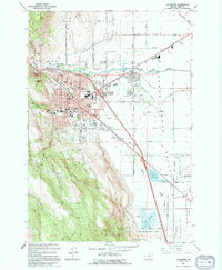
1994 Map of La Grande
USGS Topo · Published 1994About this map
The Grande Ronde Valley serves as the backdrop for this mid-1990s look at La Grande, where the Union Pacific railroad and Grande Ronde River converge. The town's layout is meticulously detailed, showing the campus of Eastern Oregon State College, the Grande Ronde Hospital, and several local education centers like Riveria Sch and Greenwood Sch. To the southeast, the landscape transitions into the expansive Ladd Marsh Game Management Area, a significant wetland complex marked by Ladd Marsh and Gekeler Slough. Cultural and genealogical landmarks are prominent, including Ackles Cem, Island City Cem, and Hillcrest Cem. The map captures the infrastructure of the era, from the La Grande Airport to the Drive-in Theater and the La Grande Ranger Station, illustrating a hub of commerce and conservation in Union County.
Find a feature on this map
97 named features on this map. Tap any name to fly to it.
Don’t see what you’re looking for? This feature index may not catch every label — zoom into the map to look around manually.
Map Details
Editions of this 1994 La Grande Map
This is the sole edition of this map. No revisions or reprints were ever made.
Other maps of this area

1906 · Telocaset
USGS Topo · 1:125,000

1953 · Pendleton
USGS Topo · 1:250,000

1955 · Grangeville
USGS Topo · 1:250,000

1956 · Pendleton
USGS Topo · 1:250,000

1959 · Grangeville
USGS Topo · 1:250,000

1963 · La Grande SE
USGS Topo · 1:24,000

1963 · Hilgard
USGS Topo · 1:24,000

1963 · Summerville
USGS Topo · 1:24,000

1964 · Drumhill Ridge
USGS Topo · 1:24,000

1965 · Conley
USGS Topo · 1:24,000