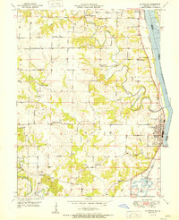
1951 Map of La Grange
USGS Topo · Published 1951About this map
The Mississippi River defines the eastern edge of this Lewis County landscape, where the Chicago Burlington and Quincy railroad tracks run parallel to the water's edge through Canton and La Grange. The interior is shaped by the winding paths of the Wyaconda River and North Fabius River, creating a network of ridges and bottoms that supported a dense system of rural schools. Names like Pink Prairie Sch, High Hill Sch, and Bozarth Sch indicate the importance of these local school districts in the mid-century community.
Find a feature on this map
32 named features on this map. Tap any name to fly to it.
Don’t see what you’re looking for? This feature index may not catch every label — zoom into the map to look around manually.
Map Details
Editions of this 1951 La Grange Map
This is the sole edition of this map. No revisions or reprints were ever made.
Other maps of this area

1903 · Kahoka
USGS Topo · 1:125,000

1903 · Palmyra
USGS Topo · 1:125,000

1925 · Quincy
USGS Topo · 1:62,500

1944 · Quincy
USGS Topo · 1:62,500

1945 · Quincy
USGS Topo · 1:62,500

1946 · Mendon
USGS Topo · 1:62,500

1948 · Quincy
USGS Topo · 1:250,000

1948 · Mendon
USGS Topo · 1:62,500

1949 · Durham
USGS Topo · 1:24,000

1949 · Maywood
USGS Topo · 1:24,000