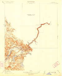
1919 Map of La Grange
USGS Topo · Published 1922About this map
La Grange serves as the focal point of this 1915 survey, situated where the gold-bearing Sierra foothills meet the eastern Central Valley. The town, marked with a benchmark elevation of 258 feet, overlooks the powerful Tuolumne River as it passes the La Grange Dam. This landscape is defined by the early development of irrigation and mining infrastructure, notably the Modesto Ditch and several named ravines such as Snake Ravine and Mortar Gulch. Local education and transit are represented by the Live Oak School to the north and the river crossing at Basso Bridge. The map captures a transition in water management, tracing the river's winding path past Twin Gulch into unsurveyed territory, while family-named features like Johnson Creek and Domenicini Gulch reflect the settled agricultural and mining history of Stanislaus and Tuolumne Counties.
Find a feature on this map
24 named features on this map. Tap any name to fly to it.
Don’t see what you’re looking for? This feature index may not catch every label — zoom into the map to look around manually.
Map Details
Editions of this 1919 La Grange Map
3 editions found

Other maps of this area

1893 · Sonora
USGS Topo · 1:125,000

1896 · Sonora
USGS Topo · 1:125,000

1897 · Sonora
USGS Topo · 1:125,000

1898 · Sonora
USGS Topo · 1:125,000

1913 · Dickenson
USGS Topo · 1:31,680

1915 · La Grange
USGS Topo · 1:24,000

1916 · Three Tree Flat
USGS Topo · 1:31,680

1916 · Cooperstown
USGS Topo · 1:31,680

1916 · Copperopolis
USGS Topo · 1:62,500

1916 · Merced Falls
USGS Topo · 1:24,000