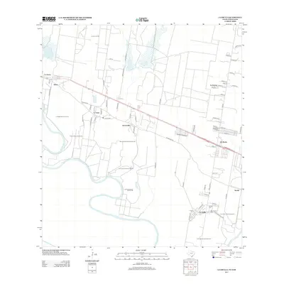
2013 Map of La Grulla
USGS Topo · Published 2013About this map
The Rio Grande carves a complex international boundary through this portion of Starr County, leaving behind distinctive river features such as San Francisco Banco Number 60 and Los Fresnos Banco Number 145. The settlement pattern follows the high ground north of the floodplain, where established communities like La Grulla and Garciasville are connected by the Old Military Road. In the northern reaches, the La Union Oil Field points to the region's petroleum industry, while numerous family-named roads like Mancias Lane and Rodriguez Lane reveal the agricultural and residential fabric of the area. Genealogists will find significant value in the documentation of local burial grounds, including Longoria Cemetery, Solizes Cemetery, and San Vicente Cemetery, which serve as vital markers for family history in these riverside communities.
Find a feature on this map
72 named features on this map. Tap any name to fly to it.
Don’t see what you’re looking for? This feature index may not catch every label — zoom into the map to look around manually.
Map Details
Editions of this 2013 La Grulla Map
This is the sole edition of this map. No revisions or reprints were ever made.
Other maps of this area

1949 · Mc Allen
USGS Topo · 1:250,000

1954 · McAllen
USGS Topo · 1:250,000

1956 · Garcias
USGS Topo · 1:62,500

1956 · Los Ebanos
USGS Topo · 1:62,500

1956 · Escobares
USGS Topo · 1:62,500

1957 · Mc Allen
USGS Topo · 1:250,000

1962 · McAllen
USGS Topo · 1:250,000

1965 · Rio Grande City South
USGS Topo · 1:24,000

1965 · La Grulla
USGS Topo · 1:24,000
1965 · Sullivan City
USGS Topo · 1:24,000