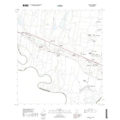
2019 Map of La Grulla
USGS Topo · Published 2019About this map
The Rio Grande snakes along the international boundary between the United States of America and Mexico in this recent survey of Starr County. The landscape is characterized by a dense network of residential colonias and named family settlements that line the corridors of FM 1430 and the Old Military Rd. Settlements like La Grulla, Garciasville, and Alto Bonito are established hubs, while smaller developments such as Solis Colonia and Venecia Colonia reflect the continued growth of these communities near the river. Genealogists will find significant local value in the presence of several established burial grounds, including San Vicente Cem, Solizes Cem, and Longoria Cem, which are situated near the town centers. The map also details the transition from irrigated riverside land to the interior brush country, marked by features like Salado Cr and Loma Blanca Rd.
Find a feature on this map
82 named features on this map. Tap any name to fly to it.
Don’t see what you’re looking for? This feature index may not catch every label — zoom into the map to look around manually.
Map Details
Editions of this 2019 La Grulla Map
This is the sole edition of this map. No revisions or reprints were ever made.
Other maps of this area

1949 · Mc Allen
USGS Topo · 1:250,000

1954 · McAllen
USGS Topo · 1:250,000

1956 · Garcias
USGS Topo · 1:62,500

1956 · Los Ebanos
USGS Topo · 1:62,500

1956 · Escobares
USGS Topo · 1:62,500

1957 · Mc Allen
USGS Topo · 1:250,000

1962 · McAllen
USGS Topo · 1:250,000

1965 · Rio Grande City South
USGS Topo · 1:24,000

1965 · La Grulla
USGS Topo · 1:24,000
1965 · Sullivan City
USGS Topo · 1:24,000