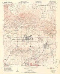
1952 Map of La Habra
USGS Topo · Published 1952About this map
La Habra and the surrounding orange and oil country are captured here just as post-war suburbanization began to accelerate across the Los Angeles and Orange County line. The landscape is a distinct blend of agricultural heritage and industrial extraction, where extensive networks of oil wells dot the Puente Hills and Coyote Hills, standing alongside established estates like Murphy Ranch and Sunny Hills Ranch. The central corridor is defined by the Pacific Electric and Union Pacific Railroad lines, which supported the citrus and petroleum economies of Brea and Fullerton.
Find a feature on this map
58 named features on this map. Tap any name to fly to it.
Don’t see what you’re looking for? This feature index may not catch every label — zoom into the map to look around manually.
Map Details
Editions of this 1952 La Habra Map
2 editions found
Other maps of this area

1894 · Los Angeles
USGS Topo · 1:62,500

1894 · Pomona
USGS Topo · 1:62,500

1896 · Pasadena
USGS Topo · 1:62,500

1896 · Anaheim
USGS Topo · 1:62,500

1896 · Downey
USGS Topo · 1:62,500

1897 · Pomona
USGS Topo · 1:62,500

1898 · Pomona
USGS Topo · 1:62,500

1898 · Anaheim
USGS Topo · 1:62,500

1899 · Downey
USGS Topo · 1:62,500

1900 · Pasadena
USGS Topo · 1:62,500