
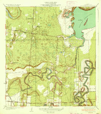
1930 Map of La Leona
USGS Topo · Published 1930About this map
The tidal flats and ranchlands of coastal Cameron County are captured here in an era of transition, documented by county engineer W. O. Washington and others just before the turn of the decade. The landscape is defined by the winding course of the Arroyo Colorado, which carves through the northern reaches of the quadrangle near the Willacy and Cameron county line. Large-scale ranching operations anchor the local geography, with La Leona Ranch, Los Coyotes Ranch, and Nuevo Ranch serving as primary landmarks in this sparsely populated coastal prairie. To the east, the map details the intricate shoreline of Cayo Atascoso and the broader waters of Laguna Atascosa, showcasing a region defined by its hydrological complexity and expansive salt flats.
Find a feature on this map
7 named features on this map. Tap any name to fly to it.
Don’t see what you’re looking for? This feature index may not catch every label — zoom into the map to look around manually.
Map Details
Editions of this 1930 La Leona Map
This is the sole edition of this map. No revisions or reprints were ever made.
Other maps of this area

1929 · Rio Hondo
USGS Topo · 1:24,000

1929 · La Coma
USGS Topo · 1:24,000

1929 · Buena Vista
USGS Topo · 1:24,000

1930 · Laguna Atascosa
USGS Topo · 1:24,000

1932 · Rio Hondo
USGS Topo · 1:31,680

1933 · Paso Real
USGS Topo · 1:31,680

1934 · La Coma
USGS Topo · 1:31,680

1935 · Buena Vista
USGS Topo · 1:31,680

1936 · La Leona
USGS Topo · 1:31,680
1936 · Laguna Atascosa
USGS Topo · 1:31,680
Featured Places
- Coulson Colonia, TX
- Rancho Nuevo, TX
- Arroyo City Subdivision Colonia, TX
- La Leona, TX
- Los Coyotes Ranch, TX