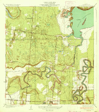
1936 Map of Laguna Atascosa
USGS Topo · Published 1936About this map
Meandering ancient waterways and established cattle spreads dominate this coastal South Texas landscape. The intricate oxbow curves of Resaca De Los Fresnos and Resaca De Los Cuates illustrate the region's complex hydrology, winding through a terrain dotted with prominent family ranches such as El Alazan Ranch, San Pedro Ranch, and the San Jose Ranch. The shoreline is defined by the expanse of Laguna Atascosa and the marshy inlet of Cayo Atascoso, while the interior shows the transition toward organized land development with Share No 27 Road and Share No 31 Road. Industrial infrastructure is represented by the Missouri Pacific Railroad cutting through the southwest near the settlement of Lacoma, providing a vital link for the agricultural and ranching economies of Cameron County.
Find a feature on this map
24 named features on this map. Tap any name to fly to it.
Don’t see what you’re looking for? This feature index may not catch every label — zoom into the map to look around manually.
Map Details
Editions of this 1936 Laguna Atascosa Map
2 editions found
Other maps of this area

1929 · Rio Hondo
USGS Topo · 1:24,000

1929 · La Coma
USGS Topo · 1:24,000

1929 · Buena Vista
USGS Topo · 1:24,000

1929 · Laguna Vista
USGS Topo · 1:24,000

1930 · Los Fresnos
USGS Topo · 1:24,000

1930 · Barreda
USGS Topo · 1:24,000

1930 · La Leona
USGS Topo · 1:24,000

1930 · Laguna Atascosa
USGS Topo · 1:24,000

1932 · Rio Hondo
USGS Topo · 1:31,680

1933 · Paso Real
USGS Topo · 1:31,680
Featured Places
- Bayview, TX
- Lourdes Street Colonia, TX
- Esquina Colonia, TX
- Arroyo Gardens Number 2 Colonia, TX
- La Tina, TX