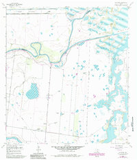
1955 Map of La Leona
USGS Topo · Published 1984About this map
Arroyo City and the winding Arroyo Colorado anchor this landscape in coastal Cameron County, showing the complex water management systems of the mid-20th century. The map illustrates a transition from the agricultural operations of La Leona Ranch and Rancho Nuevo to the preserved wetlands of the Laguna Atascosa National Wildlife Refuge. Traces of local heritage are preserved at the La Leona Cem, located south of the Fernando East Road. The terrain is defined by a network of drainage features, including the North Floodway and Cayo Atascoso, alongside numerous named stock tanks like Los Patos Tank and Jasper Tank. This survey, revised in 1955 with 1980s updates, documents the essential infrastructure of South Texas ranching and water control, from the Pilot Channel to the many levees and ditches that shaped the coastal prairie.
Find a feature on this map
36 named features on this map. Tap any name to fly to it.
Don’t see what you’re looking for? This feature index may not catch every label — zoom into the map to look around manually.
Map Details
Editions of this 1955 La Leona Map
4 editions found
Other maps of this area

1929 · Rio Hondo
USGS Topo · 1:24,000

1929 · La Coma
USGS Topo · 1:24,000

1929 · Buena Vista
USGS Topo · 1:24,000

1930 · La Leona
USGS Topo · 1:24,000

1930 · Laguna Atascosa
USGS Topo · 1:24,000

1932 · Rio Hondo
USGS Topo · 1:31,680

1933 · Paso Real
USGS Topo · 1:31,680

1934 · La Coma
USGS Topo · 1:31,680

1935 · Buena Vista
USGS Topo · 1:31,680

1936 · La Leona
USGS Topo · 1:31,680
Featured Places
- Coulson Colonia, TX
- Rancho Nuevo, TX
- Arroyo City Subdivision Colonia, TX
- La Leona, TX
- Los Coyotes Ranch, TX