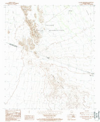
1988 Map of La Lesna Mountains
USGS Topo · Published 1988About this map
Papago Indian Reservation lands dominate this late-twentieth-century study of the Sonoran borderlands, where the La Lesna Mountains form a rugged spine across the landscape. The geography is defined by the international boundary between the United States of America and Mexico, with the Sierra La Lesna extending south into Sonora. Small settlements like Ak Komelik and Sivili Chuchg are connected by a network of 4WD trails that traverse the arid expanses of The Great Plain and Tecolote Valley. This map is particularly notable for capturing the rural infrastructure of the Tohono O'odham nation, including the remote location of Tatum Vo and Serapio, providing a detailed look at the persistence of these communities in the high desert before modern development altered the traditional access routes.
Find a feature on this map
15 named features on this map. Tap any name to fly to it.
Don’t see what you’re looking for? This feature index may not catch every label — zoom into the map to look around manually.
Map Details
Editions of this 1988 La Lesna Mountains Map
This is the sole edition of this map. No revisions or reprints were ever made.
Other maps of this area

1954 · Sonoyta
USGS Topo · 1:250,000

1963 · Kom Vo
USGS Topo · 1:62,500

1963 · Gu Oidak
USGS Topo · 1:62,500
1963 · La Lesna Mts.
USGS Topo · 1:62,500

1963 · Lukeville
USGS Topo · 1:250,000
1988 · Chukut Kuk
USGS Topo · 1:24,000
1988 · Tecolote Ranch
USGS Topo · 1:24,000
1988 · Kots Kug Ranch
USGS Topo · 1:24,000
1988 · South of Papago Farms
USGS Topo · 1:24,000
1988 · Papago Farms
USGS Topo · 1:24,000
Featured Places
- Chukut Kuk District, AZ
- Sivili Chuchg, Chukut Kuk District
- Ak Komelik, Chukut Kuk District
- Pima County, AZ