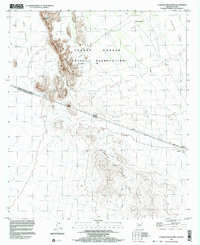
1996 Map of La Lesna Mountains
USGS Topo · Published 2003About this map
The international boundary between the United States of America and Mexico bisects this desert landscape, where the La Lesna Mountains of Arizona meet the Sierra La Lesna of Sonora. Located within the Tohono O'odham Indian Reservation, the map records several tribal settlements and sites of cultural importance, including Ak Komelik and Sivili Chuchg. To the north, a small Cem sits near the base of the mountains, while the eastern reaches of the sheet follow the Tecolote Valley. The terrain transitions from the steep rise of La Lesna Peak to the expansive flats of The Great Plain, providing a detailed look at the 4WD tracks and cattle infrastructure like the various Corral sites that supported the local ranching and transit across this borderland region.
Find a feature on this map
16 named features on this map. Tap any name to fly to it.
Don’t see what you’re looking for? This feature index may not catch every label — zoom into the map to look around manually.
Map Details
Editions of this 1996 La Lesna Mountains Map
This is the sole edition of this map. No revisions or reprints were ever made.
Other maps of this area

1954 · Sonoyta
USGS Topo · 1:250,000

1963 · Kom Vo
USGS Topo · 1:62,500

1963 · Gu Oidak
USGS Topo · 1:62,500
1963 · La Lesna Mts.
USGS Topo · 1:62,500

1963 · Lukeville
USGS Topo · 1:250,000
1988 · Chukut Kuk
USGS Topo · 1:24,000
1988 · Tecolote Ranch
USGS Topo · 1:24,000
1988 · Kots Kug Ranch
USGS Topo · 1:24,000
1988 · South of Papago Farms
USGS Topo · 1:24,000
1988 · Papago Farms
USGS Topo · 1:24,000
Featured Places
- Chukut Kuk District, AZ
- Sivili Chuchg, Chukut Kuk District
- Ak Komelik, Chukut Kuk District
- Pima County, AZ