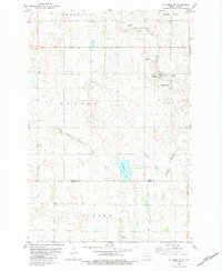
1982 Map of La Moure SW
USGS Topo · Published 1983About this map
The agricultural landscape of the North Dakota plains is defined here by the winding course of Cottonwood Creek and its South Branch. In the early 1980s, the rural character of this region was centered around organized communal living and small-scale infrastructure, notably the Hutterite Colony located in the northeast. This settlement, accompanied by its own Sewage Disposal Pond, illustrates the self-contained nature of these communities within the larger prairie grid.
Find a feature on this map
16 named features on this map. Tap any name to fly to it.
Don’t see what you’re looking for? This feature index may not catch every label — zoom into the map to look around manually.
Map Details
Editions of this 1982 La Moure SW Map
This is the sole edition of this map. No revisions or reprints were ever made.
Other maps of this area

1894 · Monango
USGS Topo · 1:62,500

1894 · La Moure
USGS Topo · 1:62,500

1894 · Fullerton
USGS Topo · 1:62,500

1895 · Lamoure
USGS Topo · 1:125,000

1896 · Edgeley
USGS Topo · 1:125,000

1918 · La Moure
USGS Topo · 1:125,000

1925 · Edgeley
USGS Topo · 1:125,000

1952 · Grand Rapids
USGS Topo · 1:24,000

1953 · Jamestown
USGS Topo · 1:250,000

1955 · Fullerton NE
USGS Topo · 1:24,000
Featured Places
- Dean Township, ND
- Wright Township, ND
- Henrietta Township, ND
- Badger Township, ND
- Grand Rapids Township, ND