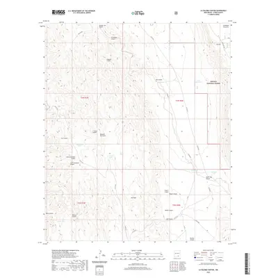
2020 Map of La Paloma Canyon
USGS Topo · Published 2020About this map
Lincoln National Forest occupies the eastern reaches of this high-desert landscape, where the dramatic escarpment of the Guadalupe Rim and The Rim mark a sharp transition in elevation within the Guadalupe Mountains. The terrain is defined by a dense network of drainages, including the central La Paloma Canyon, Kingston Canyon, and the deep Upper Dog Canyon. These canyons cut through the southern portion of the Brokeoff Mountains, a region characterized by significant landforms like Big Ridge. Settlement in this arid environment is historically tied to water management, evidenced by named catchment features such as Arch Lewis Tank, Box Tank, and Lewis Tank. A series of rural routes, including Co RD g014 and Co RD g013, provide the primary access through this remote section of Otero County, tracing the natural contours of the canyons and ridges.
Find a feature on this map
40 named features on this map. Tap any name to fly to it.
Don’t see what you’re looking for? This feature index may not catch every label — zoom into the map to look around manually.
Map Details
Editions of this 2020 La Paloma Canyon Map
This is the sole edition of this map. No revisions or reprints were ever made.
Other maps of this area

1935 · El Paso Gap
USGS Topo · 1:62,500

1936 · El Paso Gap
USGS Topo · 1:48,000

1940 · El Paso Gap
USGS Topo · 1:62,500

1943 · Texas Hill
USGS Topo · 1:62,500

1945 · Texas Hill
USGS Topo · 1:62,500

1954 · Carlsbad
USGS Topo · 1:250,000

1958 · Carlsbad
USGS Topo · 1:250,000

1963 · Gowdy Ranch
USGS Topo · 1:24,000
1969 · Sheep Draw
USGS Topo · 1:24,000
1969 · Cienega School
USGS Topo · 1:24,000